The Resolute Bay Incoherent Scatter Radars (RISR-N and RISR-C)
Resolute Bay, located in the Territory of Nunavut on the south of Cornwallis Island at almost 75oN latitude, is the gateway to the Canadian High Arctic.
This location satisfies the original scientific goals of the Polar Cap Observatory by enabling measurements in the region where coupling occurs between the solar wind and Earth’s magnetosphere, ionosphere, and thermosphere.
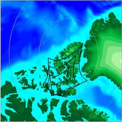
The NSF AMISR system in Resolute (RISR-N) points deep into the polar cap. The figure to the left shows the grating-lobe free coverage of RISR-N at 100, 200, 300, and 400 km altitudes (in black) as well as the magnetic latitude contours.
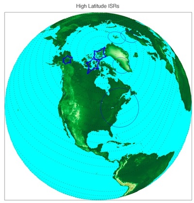
The University of Calgary has also built an AMISR face for the Resolute Bay location, known as the Canadian Resolute Bay Incoherent Scatter Radar (RISR-C). Together, the two RISR faces make routine measurements of polar cap electrodynamics and provide the data needed to understand the coupling and its global effects. The chosen orientations of the antennas will maximize the F-region convection coverage and extend the measurement latitudinal capability by using the other existing high-latitude ISR facilities. The shows the coverage of RISR-N, RISR-C, PFISR, and the ISRs at Sondrestrom, the European Incoherent Scatter radars (EISCAT), the EISCAT Svalbard Radar (ESR), and Millstone Hill, all at 400 km altitude. These RISR antenna orientations provide excellent polar cap convection coverage, especially considering the combination of the EISCAT, ESR, and Sondrestrom radars.